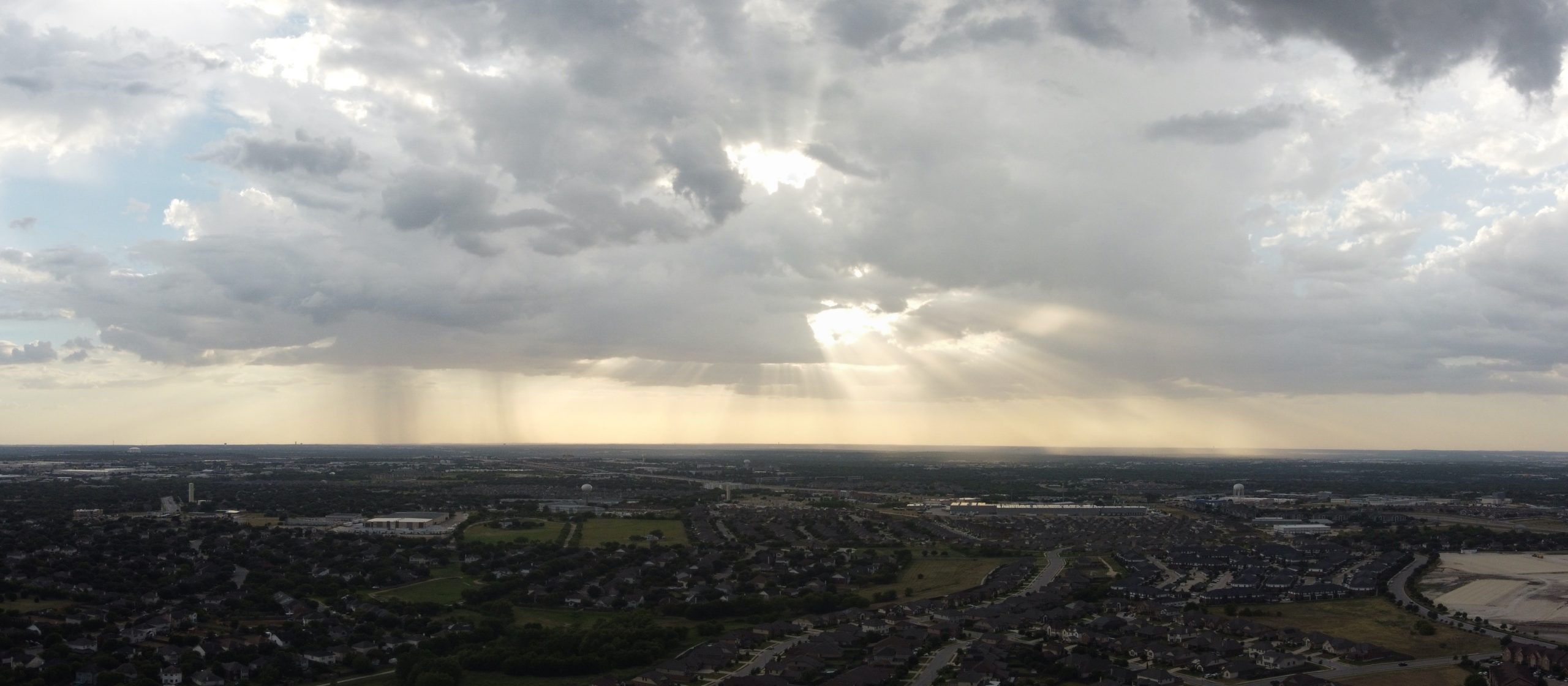
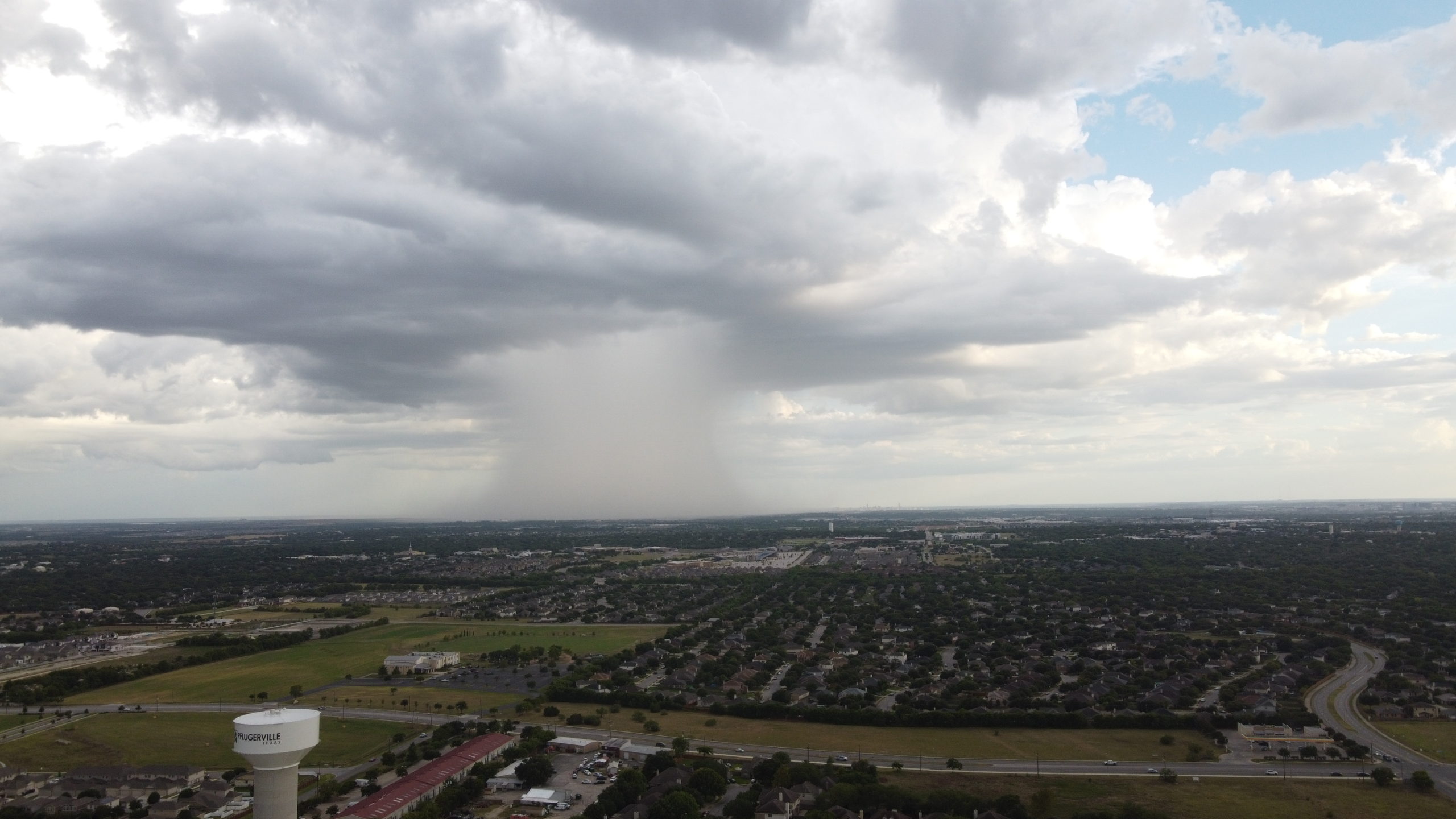
I’ve come to love weather photos from the perspective of a 400 ft high drone. We’ve had some pretty exciting storms recently and I was having so much fun taking pictures of the storms brewing around me that I had to scramble to land before things got too crazy.
These photos look pretty nice when viewed full screen — just click on them. While getting a shot of one of the approaching rain storms I saw the drone start to drift in the wind and I felt and smelled a front come in. I dove to the ground quickly and moments later we had 45 degree rain.
I’ve always been intrigued by construction processes. I watched a nearby construction site mutate on a weekly basis with piles of dirt moving from one end to the other and then back, wondering what in the heck is the purpose of all of that. Anyway, my recent purchase of a Mavic Mini has allowed me to spy on construction sites in progress.
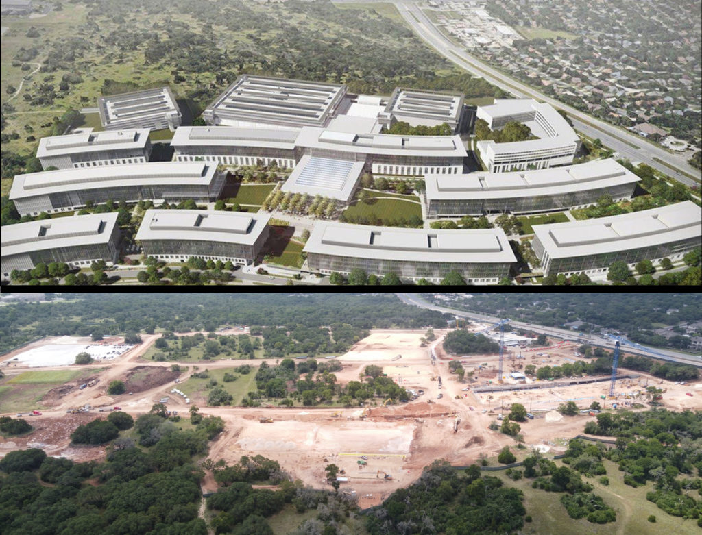
For example, Apple has started work on a huge new campus here in Austin Texas. A couple of weeks ago massive cranes showed up. From the road you really can’t see much of anything, but with a drone, you can get a birds-eye view of things.
Construction site for the new Austin Campus being built by Apple – as of July 7, 2020
Even with an artists rendering of the plan I still can’t really identify the areas of the construction. I’ve done my best to match my photo up with the position and perspective of the rendering. I’ve gotten used to using the “Panorama Stitching Mini” app, and due to the size of the construction site, I had to use the tool to build a view that includes roughly the same area as the rendering.
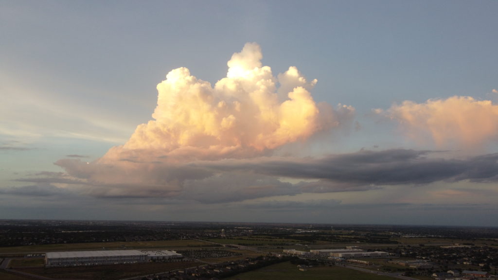
Spectacular cloud over Living Spaces in Pflugerville
I was trying to get over my fear of high-winds while flying my drone — see the story about almost losing it. I’ll tell you what I learned about flying in high winds, but first, I noticed some beautiful clouds forming. I’ve taken pictures of storm clouds before, but always from the ground. I like this perspective much better. It’s nice to see the ground. Sometimes, I’ve been able to see the cloud and it’s shadow, very cool.
A panoramic of clouds forming East of Pflugerville
I’ve been doing a bit of experimenting, and here’s what I’ve learned about flying the Mavic Mini in high winds:
It does quite well at holding its position in moderate wind. I suspect that there are places where that’s not good enough — like a beach. If that’s important to you then buy a more expensive drone.
You might see dozens of “High Wind” warning messages without it being an issue.
Watch the “speed” readout. As long as it’s wobbling no more than 0.3 mph you’re probably fine, but winds change ..uh.. like the wind. You can suddenly be drifting away at several mph. Best not to panic.
If it absolutely cannot hold its position, it will not return to where it was, even when the wind calms down. Update: At least for about 100 feet it will try to return to where it was, but it requires great self-discipline to not interfere with that. I’m pretty sure as soon as you move the controls it’s going to forget where it was trying to be. So it’s up to you to “head home” when the wind is calm as fast as you can.
Of course, dropping altitude is probably the best plan to regain control but, in my first incident, that didn’t help. I went down to ~30 ft and was still losing ground.
Winds tend to be gusty. Try to regain ground between gusts. Unfortunately, you can only know when that is if you let go of the stick and watch the speed readout.
By listening to the motor noise, I think it is more efficient about fighting winds when facing away from the wind, not heading into the wind. It kind of makes sense to me if you think about the positioning of the propellers and how they might interfere with each other when pitched downwards.
You will have a better chance of fighting a stiff wind if you are dropping altitude at the same time, since the motors aren’t working as hard. You should also be in “Sport” mode while trying to fight the wind. I don’t think it matters for station keeping, but I think it does when you’re trying to regain lost ground between wind gusts.
It’s easiest to see that you’re losing ground if you point the camera straight down, but you better be familiar with where you are and where you need to be if you’re going to be fighting the wind.
Interestingly, you can see symptoms that the drone is working hard to hold its position. For instance, if it’s facing away from the wind and you have the camera pointed straight down, the camera will suddenly raise several degrees. That’s because the gimbal doesn’t go any further than straight down and the drone has tilted to fight the wind.
Update: Even though the drone warns “Unable to use Return To Home”, it’s not true. If you’re panicky or disoriented, mash that “RTH” button and let it fight the wind for you. I noticed that you can still control the rotation of the drone and the gimbal position while it is returning. As mentioned earlier I think that pointing the drone away from home will improve it’s ability to fight the wind. BTW, don’t be concerned with the accuracy of the “home point”, all you want to do is get it close enough to you that you can cancel the RTH and land it yourself.
Well, no profit for me. You have to have a license to fly commercially but this was fun anyway. My brother is selling his house (in Waco) so I drove up there and shot some video with the drone. Yes, even the indoor shots were done with the drone — while I held it on top of my head! Turns out drones make a decent steadicam even when they’re not flying.
After you’ve peeked at all of the neighbors backyard landscaping (or their clutter), satisfied your curiosity about what’s behind that 8-foot wall, checked out what the top of a water tower actually looks like, what’s next?
Well, I’ve been practicing flying more gracefully for one thing. And I got to use it last week when I shot some video for my brother, who’s selling his house. I’ll post a bit about that another time. This week I got distracted by a different idea — data collection.
Now I’m not the first to think of a drone as a data collection device. There’s plenty of farmers that are monitoring their crops with drones that fly preprogrammed patterns over their land, and construction companies that have automated drones that track their progress and validate that plans are being followed. Frankly, I think this is a giant industry that is just now getting figured out — I should probably buy some stock.
But in my own little world I like to push my technology (i.e. toys) to its limit, or at least think wistfully about the possibilities. How many people in my neighborhood park their cars on the street? How many in the driveway? How many don’t move for days? These are trivial questions not even worth thinking about, right? But wait, could I actually answer them?
DJI sells a wide range of drones. The Mavic Mini that I have is one of the lowest models they offer, but they have some sophisticated drones that can certainly be programmed to autonomously gather such data. There’s a few pieces of the puzzle that require extra effort but it can be done. One of the things that makes this possible is that DJI drones actually have a developer’s API. That means 3rd party apps can be used to control the drones. The Mavic Mini isn’t yet supported by the API, but it’s supposed to be coming out soon. It’s still a cheap, pretty limited drone, but how much could I accomplish?
So I spent a few days reading on the topic. There are some sophisticated companies already providing solutions for some of this stuff. But I’m cheap… what can I do on the cheap? Turns out there’s a pretty popular package called Open Drone Map and it’s shockingly easy to use.
The idea is to stitch together images (still images) from a drone and correlate them to actual GPS coordinates, and present the results as a data-set. Once you’ve done that you can map terrain, count cows (or cars), look for sick crops, or figure out how far along a giant construction project is. Some companies use thermal cameras or custom made drones to gather their data.
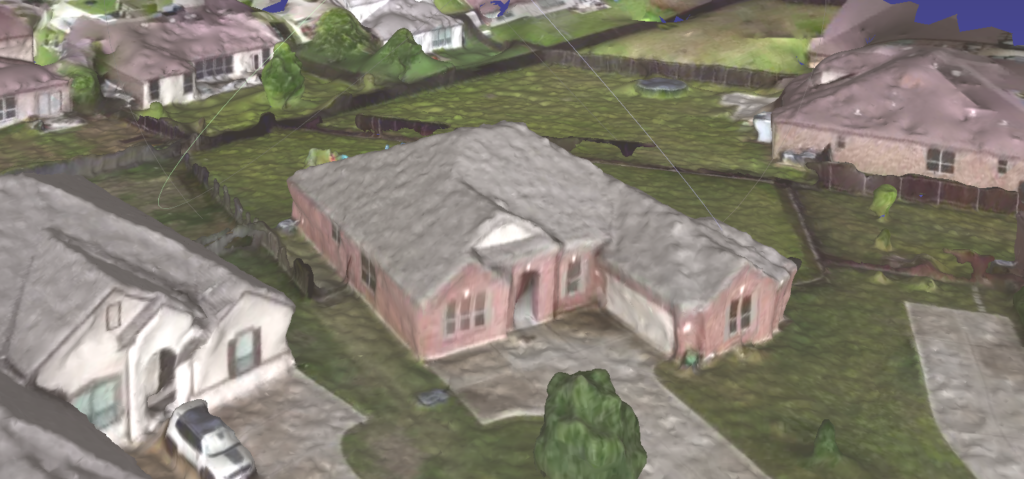
What I wanted to know first was if this software would be useful with my lowly Mavic Mini (basically a toy drone) and whether I would even be able to get it running. Totally as an experiment, I decided to play with the video that I had already shot from the drone doing a circle maneuver over my house (see a previous post).
It turns out my Mac Book Pro may be the limiting factor. I have 52 seconds of 2.7K video at 30 fps. I used FFMPEG to convert my video into ~1500 horribly low quality still images. I knew 1500 images would take forever even if it did work so I threw out 9/10ths of the images and tried processing 150 of them. The docker command I found went right to work on the images but quickly died — out of memory. I cut that down to about 75 images and scaled them down by half (i.e. 1/4th of the pixels) since the quality was so bad to begin with. I tried again and it worked! Oh my, it ran in less than 2 hours and I wasn’t even sure what to do with the result. I found that it produces an OBJ file and I found Mesh Lab to display my house as a 3D Object — I was very excited and took the above screen shot. It took me the rest of the day to figure out how to put it on the web. I used three.js to throw together this quick demo.
It’s not great, but give me some credit here… I used video (not stills) from a very cheap drone, threw out 95% of the frames and 3/4ths of the pixels, ran free software with no installation under docker on my under-powered Mac Book Pro, and wrote some hasty Javascript (not my language of choice) using a free library that I’ve never used before. I think that’s quite a lot of progress for a day’s work.
So far, I’ve flown 42 times for over 7 hours. In all this time, I had never had a challenging situation. I usually ended up landing with about 35% battery left and had learned not to panic when I see a “strong wind warning”. In every other case, dropping 50 feet or so would make the warnings go away and I had never seen the drone drift significantly off of it’s course.
Today the “UAV Forecast” app told me “Not Good to Fly”. It said the winds were really strong even down at low altitude. But when I stopped working and stepped outside it was very calm. Now I don’t know the technology behind the app, but I figured it was probably a “prediction” not really a report of current conditions. So with all this confidence I launched from my back porch. I popped up to 150 feet and hovered for a while to see if it had any issues and it did not. So I got over a nearby greenbelt and flew to both ends of it with no issue, maybe a half-mile to the North and a half-mile to the South. To maintain my radio signal I even went up to about 300 feet. At around 40% battery life I decided to start heading home, and everything was going fine until I got just a couple of blocks away.
I started getting strong wind warnings and drifting to the South. I dropped down to 100 feet and was pushing full throttle against the wind and still losing ground. I dropped down to 50 feet, still losing ground, and now the battery was going down fast. My hands were shaking, I couldn’t think clearly, the fence was locked, I ran through the house and out the front door, I was flying as low as I thought I safely could not really knowing where I was. I pointed the camera down, and before I could make a decision about the street I saw it was gone. I saw a line of trees go by and then saw what looked like grass. At this point, I was losing my radio connection and the battery was critical so I didn’t have much choice but to let it do it’s emergency landing.
I was full of adrenaline and running down the street. I was afraid it would land and be impossible to find, or land in someone’s yard that I wouldn’t be able to recover, or worse, it could have landed in a tree or on a building or even hurt someone or damage something. According to the app, it was in the greenbelt, that was a relief but I was still concerned about it sitting unattended in a field. So, here I am, in shorts, running through bushes and 4-foot high grasses, negotiating around a not-quite dry stream. I get through the tree-line and into the field and can calm down a little bit as I try to use the app to help me find the thing. The compass on my phone absolutely sucks and I’m walking in circles in the field and the app offers to “make the drone flash and beep”. I was like 5 feet from the thing and still couldn’t see it because the grass was about a foot tall.
Thank you Lord, that could’ve been so much worse. I’ve been known to fly from my back yard with no shoes on, that would have been bad. There was a line of trees and houses on either side of this greenbelt, either would have been very bad. And while looking for it, I could have easily stepped on it or found a snake instead. All in all, I feel very lucky. It was a pretty gentle lesson to pay more attention to the wind warnings and battery level.
It’s become clear to me that the drone hobby is not really about flying, it’s mostly about video editing, which I’ve never done. So after beating my head against a Blender, I ended up using OpenShot for now. I know I have a long way to go but here’s my first stab at it.
I finally gave in and bought a drone. I think the Mavic Mini has opened up the technology to be used casually, and here’s my proof. After reading a bit and playing with it indoors (it was raining), I went outside as soon as the rain let up and made my first few videos.